
Plain language summary
Assessments of sea level rise relative to land must include the process of glacial isostatic adjustment (or GIA). GIA is the ongoing response of the Earth’s surface following the last ice age around 20,000 years ago. It means that land and ocean floor that was under or near former ice sheets continues to move very slightly up or down. This movement can be measured at specific locations by fixed global positioning system (GPS) stations but is often estimated globally using computer model simulations.
In this paper, the authors combine a computer model simulation and GPS measurements in a statistical framework to produce an improved global prediction of GIA. The statistical framework uses a Bayesian approach to update the chosen computer model simulation using the additional insight provided by a global set of GPS measurements that have first been corrected to remove all non-GIA signals.
In common with many large-scale spatial modelling applications, there are two major challenges. The first is the global scale of the application, which quickly becomes too computationally expensive for currently desktop computers. This challenge is addressed in this work by using a bespoke spatial triangulation (the way in which data are mapped onto a triangular grid), which simplifies the statistical processing and allows the framework to be run on a standard desktop computer.
The second challenge is the need to represent geospatial processes that are ‘non-stationary’; that is processes that do not tend towards a constant long-term average or spread through time. This challenge is explored by comparing two different modelling approaches that can accommodate commonly-seen non-stationary geospatial patterns: (i) a ‘subset model’ where some processes are defined only in particular regions (e.g. sea level change is only meaningful over the ocean) and (ii) a ‘partition model’ where processes are defined globally but with different characteristics in different regions (e.g. GIA is known to be important in high latitudes but negligible near the equator).
The authors compare the global prediction of GIA using both approaches, alongside the default model which assumes stationarity. The results for predicted GIA rate (“predicted GIA mean field”) and uncertainty are shown in the plots below. Based on these, the authors concluded that they would be much happier presenting the results of the partition model to geoscientists than the results of the other two models.
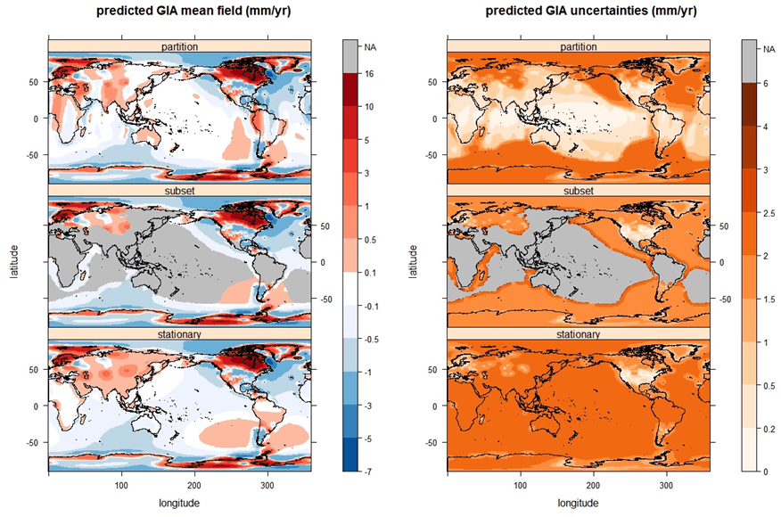
Plots showing predicted GIA rate (“predicted GIA mean field”) and uncertainty using three different models for non-stationary geospatial patterns: ‘partition’, ‘subset’ and ‘stationary’.
Download pdf version.
Full paper: Sha Z, Rougier JC, Schumacher M and Bamber JL. (2018) Bayesian model–data synthesis with an application to global glacio-isostatic adjustment. Environmetrics. 2018; e2530. (DOI: 10.1002/env.2530)
WP1 output
WP2 output